Stairway to Heaven–Skellig Michael

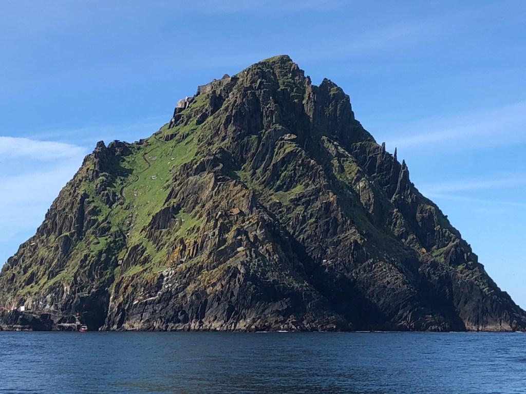
Over 600 stone steps shimmer silver under a full moon. Any less light, a night pilgrimage would be suicide ascending this steep splinter of rock rising from the sea.  My breath races as my boots seek safe purchase.

High above, torches cast golden globes of illumination from the medieval church where twelve shaved and hooded monks are dressed in rough homespun. They sing the Gregorian chant; their voices weaving an invisible Celtic design through the air, forming a veil of peace. Upwards I climb towards Christ’s Saddle, a strip of land between two 714’ peaks. With God’s grace, I’ll arrive safe.

I imagine this is what it was like long ago on the holy island of Skellig Michael. Coptic monks from Egypt built the six dry stone beehive cells and two oratories as early as the 6th century. Details are murky, but St. Fionan might have had a hand in the establishment of this and eight other monastic islands nearby. One thing is certain, in a written report, the abbot was taken by Vikings in 823 and he died of starvation in captivity. It’s interesting to me that the sweep of Orthodox Christianity sprang from Egypt, not the Roman Catholic Church. How did this odd connection happen? Most likely through trade of Irish tin into Egypt, but early pilgrimages to the Holy land were already established.

Men have wandered in and out of Great Skellig since 1,400 B.C. when mythology mentions a shipwreck and drowning of a Celtic King. Look around. He’s supposed to be buried on the island. Long ago armies regrouped here before invading the mainland. But settlement didn’t occur until the self-sufficient monk’s arrival. Why did they choose to live on a harsh, towering rock? They sought isolation for meditation, prayer, and learning but there’s ancient mysticism in the shape of Egypt’s pyramids as well as this island’s form.

Skellig Michael happens to be rich in stone for building materials and food (fish in the sea, seals, nesting birds or their eggs) but very poor in fresh water which led to an ingenious cistern and filtration system.

IMG_0802 (1)

The rectangular opening by the man’s feet is an opening to a cistern.

There’s a hidden 9th century hermitage on the north peak that I’d love to see some day. Access isn’t allowed, although I did read that “arrangements” can be made to visit it. Today, we visit the south-facing peak. The monks discovered a microclimate here for growing crops and they kept goats for meat and milk. IMG_0827

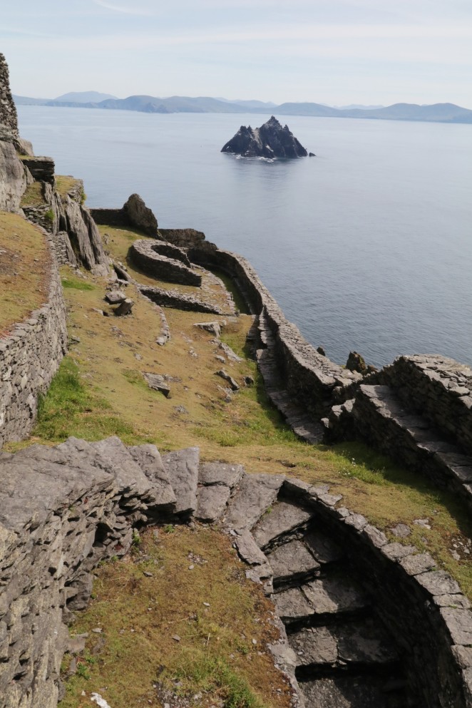
Behind the medieval church, there’s a cemetery with ancient burials and an eroded high cross. Inside the chapel there are two heartbreaking graves from 1871. The lighthouse keeper lost his two-year-old and four-year-old boys. He asked for removal from his post after his third child became sick. Through the eastern window, you can see the uninhabited bird sanctuary of Little Skellig. It is the largest protected breeding area of the northern gannet with over 30,000 pairs.

Why was the monastery abandoned? There are many answers, such as Viking raids and increased storms from climate change which also brought colder weather and less rain. Without fresh water, the island failed to support life. The entire monastic order moved to Ballinskelligs hermitage in the 13th century.

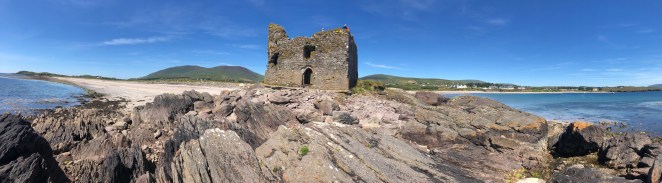
Great Skellig is 7.2 miles west of Portmagee in County Kerry on the Iveragh Peninsula.

Only a handful of captains have permits for once a day landings to the UNESCO heritage site. Go to http://www.skelligexperience.com/ for a list of excursions from May-October. You must arrange your dates well in advance as seats sell out fast. If you’re lucky, you’ll get to meet Des Lavelle, our charming expert on all things Skellig and the author of The Skellig Story. Ask him to tell you the interesting story about how he discovered the island’s past and have him autograph his book which is sold in town gift shops.

IMG_0905

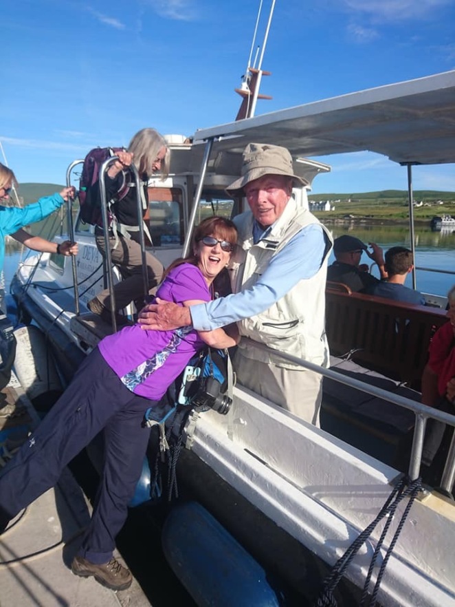
Des giving me a hug…because I’m from Montana and he has family connections in the US.

The Star Wars movies filmed here have made the island a place of pilgrimage and wonder once again. Before you disembark your boat, remember there are no facilities or services on the island. Bring hiking poles for more secure footing on the descent.

Blind Man’s Cove is where a modern dock accommodates tourists if the sea cooperates, which isn’t a sure thing. The other two sites are considered dangerous and date back to early settlement.

Puffins, razorbills, petrels and gannets breed here so your journey up and down the stones will mean stopping to take dozens of photos. One can never have enough puffin pictures.

Circling the island, grey seals rest on rocks or stick their heads out of the water to observe crazy humans in boats. IMG_0889The lighthouse seems to be perched too low and I wonder if waves pound the roof in winter. Dolphins race alongside the boat, cresting and diving in the wake and whales have been spotted.

On the way back to Portmagee, our spiritual journey took another leap. A corona formed an irridescent circle around the sun. Closing my eyes, I sang my own psalm of praise and blessing. IMG_0907After a full day of exploration, we returned to beautiful Portmagee for a fine seafood meal and live music.

Trekking Ireland–Part 2

Let’s head southwest to the Kerry Peninsula where our first stop is in Killarney to check out 15th century Ross castle. If you like, pay the entrance fee and tour inside.

Notice the steps down to the lake where a short boat trip takes us to the holy island of Innisfallen. The monastery, built in the 7th century by St. Finian the Leper, was sacked many times by the Vikings, rising each time from destruction. Most of the ruins seen today are from the 12th century.

Afterwards, drive towards Cahirsiveeen with beautiful Dingle bay on the right hand side. If you pre-plan, you’ve packed a picnic lunch to enjoy at one of the scenic overlooks. Our final destination will be Ballinskelligs–with cinema worthy beaches, amazing restaurants close by and live music in many o’pub. Stay with perfect hosts, Dom and Lillian at the old school house for great digs and the best breakfast in Ireland.  The feature sunset photo was taken in their backyard.    https://www.rascalstheoldschoolhouse.com/


Bolus Loop Walk –Ballinskelligs

7.5 km and allow 2.5 hours. This fantastic trail starts at the car park where there’s a monument to Americans who crashed an airplane into the ocean during WWII.

Walk along the country road, arriving at a short ladder into the field and keep following the purple sign markers. Slowly climb the ridge, with views across the Atlantic ocean to Skelling Michael. IMG_2004
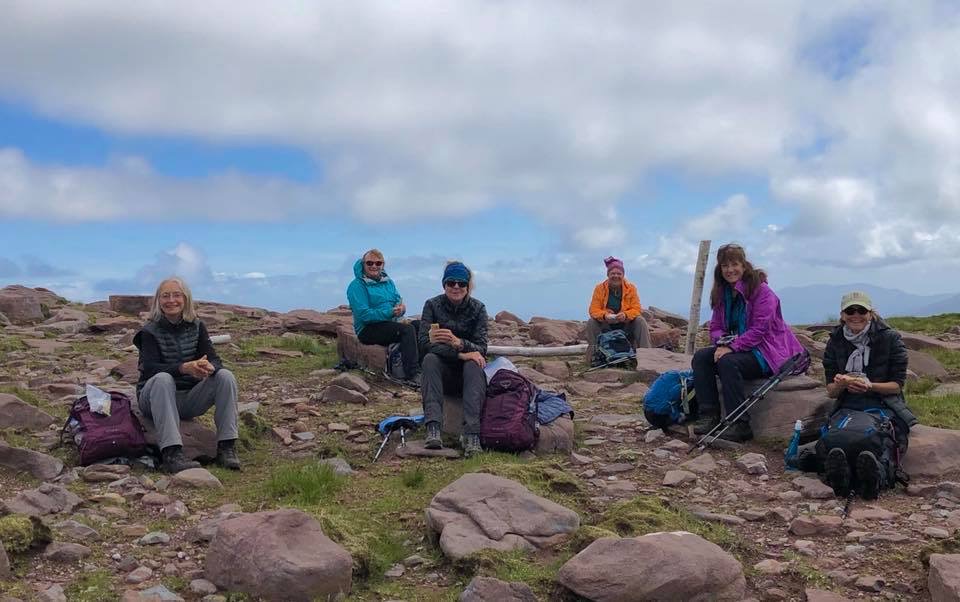
Moderate trek, steady uphill with beautiful views.  Oh—and don’t miss the Skellig chocolate factory after you’re done hiking. Definelty worth a stop!   https://www.irishtrails.ie/trail/Bolus-Barracks-Loop/612/

Bentee Loop

 Cahirsiveen

This 9 mile, moderate trail is worth every drop of sweat up “the mountain of the cross”. We started behind the gas station in Cahirsiveen, following the purple signposts to an overlook of the city for fantastic views east as well as back toward town. IMG_0927Continuing on the loop, there’s some shade while walking south until the track switches uphill and heads west.

The view at the summit is breathtaking, looking down upon Cahirsiveen, over to Portmagee,Valencia Island and to lands beyond. On a clear day, you really can see forever.

One note on the descent: about a third of the way down the hill, you’ll come to TWO purple sign markers. One heads straight downhill; the other cuts diagonally left toward the west. We couldn’t see any landmarks to help make an educated guess on which path to take and there wasn’t a trail map at that juncture. Suffice it to say that we think we took the wrong route since it took us so long to get back to town. Taking all in stride, we still found ways to entertain ourselves. The reward on a hot day was ice cream back at our starting point.


https://www.irishtrails.ie/Trail/Cahersiveen—Beentee-Loop/

 Gorgeous Ladies Beach, AKA: Ballinskelligs Beach

IMG_0805

Fabulous beaches are a well-kept secret in Ireland and Ballinskelligs has more than its share of powdery sand leading to turquoise seas. This one is special, because it comes with its own tower castle, McCarthy Mor, dating to the 15th or 16th century.

Wait! It gets better. Farther down the beach there are more ruins of a monastery, church, and graveyard. Monks abandoned Skellig Michael in the 12th century (more on the reason in the next post) and settled in this location.

The half-moon shaped beach is gorgeous with these landmarks beckoning exploration.

Yes, it was a hot day and no, we weren’t concentrating on walking. But I put in a few miles with  my camera while searching for treasures: shells, old bits of pottery, and sea glass too.IMG_1025 Behind the car park there’s a grassy area where events are held, such as the farmers or antique flea market. Performers play Celtic and folk tunes. There’s also a tourist info spot inside a café and restrooms.

Reenroe Beach

Ballinskelligs

            Start at  Reenroe Beach and continue walking another 1km down the sand, heading towards Waterville. Stop for a snack in Charlie Chaplin’s town at http://www.ancorcan.com/


Derrymore Mass Path

Catherdaniel

http://www.gokerry.ie/derrynane-mass-path/

          Driving from Ballingskellig, stop at this high pass with an amazing overlook.

Derrymore Mass Path is a 6.3 km loop trail dedicated to the Liberator, Daniel O’Connell (1775-1847) at a time when being Catholic meant a person could not marry, vote, or own land. Daniel became a crusader to fight for religious and personal rights. We started at his home in Catherdaniel. IMG_1017
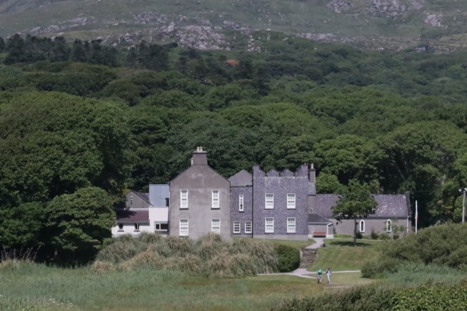
There is an entry free for the main manse, but the gardens, chapel, and some of the outbuildings are free. Start by walking the enchanting fairy trail in the garden. It is a delight for people of all ages and the most likely place for a leprechan or fairy to live.

When you’re done exploring, take the three-minute walk across the dunes to see an unbelievable turquoise sea and beaches that rival any Caribbean location. Blue skies and warm temperatures will mean a swim and nap are in order. Temptation will temporarily win the day.

After a little rest, head to the back of the beach and notice the yellow man walking posts for the Mass Path. Follow them around Derrymore bay, enjoying four beaches connected like perfect pearls between the green landscape.

In time, reach (Ahamore) Abbey Island. If the tide is out, you can walk in without getting wet. These ruins and the church yard are from the days of Saint Fionan in the 6th century. Much of the old site has been reclaimed by the sea. What exits are remains of a church with arched windows and old graves mixed with current era all around the site. The most notable person buried here is Mary O’Connell—Daniel the Liberator’s wife.

Valentia Island

Valentia is a beautiful place with plenty to explore. The lighthouse and museum at Cromwell Point is well done, explaining what life was like to live in a dangerous spot during bad storms. Follow remains of a 16th century fort while walking around the site. The Glanleam standing stone from the bronze age is located right inside of Cromwell’s star-shaped fort. I wonder what those medieval men destroyed in the process of building the military stronghold…

Geokaun Mountain and the Fogher Cliffs are the highest point of the island and there’s nice, easy walks around the hills with spectacular 360 degree views. Expect a vehicle entry fee to drive up.

Driving to the west end of the island, we tried finding St. Brendan’s Well (circa 486) where he baptized pagans, but it proved impossible. I believe there was a sign on the main road, but once we headed down, a chain stretched across the path. It looked as if we might be tresspassing on a farmer’s land, so we turned around. Maybe you’ll have better luck.

Keep tuned in! Next post the force will be with you at the holy island of Skellig Michael.

Trekking In Ireland–Part 1

Take the high road or the low, you won’t be disappointed exploring Ireland’s trekking paradise. Crest green hills for amazing vistas, be enchanted in fairyland bogs, and invigorate your soul along wild Atlantic cliff trails. Join me for a walk in the Aran Isle of Inis Mor. Next, take the ferry from Aran to Doolin to walk the cliffs of Moher. From Tralee, we’ll trek part of Saint Brendon’s (512-530A.D.) pilgrim route called the Kerry Camino on the Dingle Peninsula. In the next post–part 2–we’ll explore Ballinskellig for beautiful beach trails and high vistas before exploring Valencia Island.

Island Wanderings

InnisMor

This slideshow requires JavaScript.

This Aran island looks small, but it’s packed with ancient remains from the Iron age and early Christianity. We wanted time to experience everything in one day and still have time to hike. So we booked a local tour to see the seven churches, the location of an ancient university where Roman boys died at school and were buried in these flat tombs. The 11th century high cross marks the grave of Abbott Thomas 8th/9th century.

From there we explored impressive Dun Aonghasa, an immense stone fort built-in 1100 B.C., on a cliff  300’ above the sea. The small museum is very informative.

Later, the driver dropped us off at the trailhead for the Black Fort on the SW side of the island. The trek:  from above Cockle Strand, walk west along a cobbled path lined with beautiful dry stacked stone walls, all the way to the far edge of the island.

At the bench marking the trail, you’ll turn left and start crossing the fields, trying to stay close to the cliff edge and the sea. It takes time, because the fields are rocky. There are stone walls all over and you have to search for an opening between the walls or a place where it’s easy to step across.

To be honest, we weren’t sure we were headed in the right direction, because there aren’t any trail markers. But the views were incredible and the weather grande. Finally, the black fort wall appeared ahead. Perseverance paid off, because we had the Iron-age ruin to ourselves while waves thundered against the cliff wall below.

Expect to walk about 2 hours roundtrip back to the town of Kilronan. A three-day visit would have been better to explore this interesting island as we missed a lot. Who wouldn’t want to return to see a wormhole?

Getting here: Aran Island Ferries from Galway. Going away: Garrihy’s Doolin Aran Ferries. Both leave from Kilronan Village. Two great restaurants: Joe Watty’s Bar and Bayview Restaurant. Reservations recommended. Great pub with the best Guinness pour in all of Ireland across from the Aran Island Knit place.

Cliffs of Moher

 The entire walk is 14 km, starting from Doolin and ending at Hags Head in the south.

There’s a visitor center with an entry fee in the middle. Some people walk from Doolin to the visitor center and take a shuttle back or walk from Hags Head and do the same thing in reverse. Next time, I’d stay in Doolin for the music festival and then arrange for Sean (info below) to pick me up at the end and transfer to lands beyond. It’s important to note that the trail is narrow in spots and dangerous on a windy or rainy day. Nearby the cliffs is an odd place called Saint Bridget’s well.

It used to be a pagan spot before Christianity when St Bridget took over as the patron saint of women. *If you are following my route and arriving from the Aran Islands by ferry, contact Sean at burrentours@gmail.com for a shuttle ride down to Tralee to begin the Kerry Camino.

 Kerry Camino aka: The Dingle Way

http://kerrycamino.com/

This camino begins and ends at St. Johns church in Tralee. We spent the first night at the Grand Hotel on Denny Street https://www.grandhoteltralee.com/  I highly recommend the central location, nice restaurant, and fun pub with live music. Instead of walking like a pilgrim, we booked a one week vacation rental at beautiful Inch beach as a central spot to access trailheads. This required a rental car,  but there are some public transport and semi-private shuttle options. Check with delightful Eighlts at  e:dinglesleaheadtours@gmail.com. She dragged (rescued?) us out of a pub in Ballyferriter after we got stranded.

Living at beautiful Inch beach was worth every second of that week and I wouldn’t change a thing, even though we created a hybrid  pilg-acation, rather than a traditional camino. The light, colors, and clouds are mesmerizing and delightful. After trekking, none of us could resist putting our shoes back on and wandering up and down the beach.

Several of our team members looked carefully at the camino route, adjusting for a minimum of road walking. The asphalt is very narrow as large tour buses whip past. Tall hedges lining the roadways prevent a safe place to step away. At times it was dangerous. You’ll also notice that we did a few legs in reverse. Assessing the views while walking, I think this was the best way to photograph these segments.

* Day 1, 8.11 miles—Biennerville, from the 1800’s windmill to Camp (avoid 3 miles walking from busy Tralee). The journey starts along an undulating and more rural road. Follow the pilgrim signs uphill to a pathway. Encounter stepping-stones crossing over a wet area, but soon you’ll hop-scotch over boggy ground. Waterproof boots, pants, or gaitors are a must. Thankfully, there are several narrow bridges over rushing streams. Be sure to close gates behind you as you meander past sheep. Once you’re in the middle of the trail, signposts are difficult to see, which is irritating. I felt psychologically tired and not too keen about this segment. Like childbirth–time eases all hardship.

  • Day two -Dunquin to Ventry is about 9 km. Up and down, over and around past beautiful stone walls and ancient round forts. There’s a short stretch on a very narrow road, so hold your breath and walk fast. Turn right at the pilgrim sign onto a dirt path. This section of trail is well-marked, and will take you to the long half-moon shaped beach in Ventry. Pick up shell treasures on your way to town.
  • Day 3— Feohanagh to Mt. Brendon’s summit, ending at Brandon at a fun pub and restorative Guinness. Moderate to difficult, but one of the very best hikes. Poles are a must for the boggy (not as wet as the first leg to Camp) and somewhat steep descent from the summit. Not a place to go in bad weather. Near the bottom, a man showed us how to cut and stack peat. Allow 7 hours. and be flexible for the unexpected.
  • Day 4–Feohanagh to Smerwick and backtrack to star wars town, Ballyferriter: This is another aberration of the pilgrim route, hiking in the opposite direction of Dunquin to Feohanagh (22km). Fantastic beach walks (see pano picture below!) and Ballyferriter is a great place to be lost. There are pilgrim signs indicating the path at the back of the beach.

IMG_0774 (2)

More places to visit on Dingle:

Fitzgerald’s Minard Castle, circa 16th century, is on the Kerry Camino route but we ran short of time and drove there instead. It was destroyed by Oliver Cromwell after first blowing Walter Huseey and his men into smithereens.

Oratory of Gallarus, circa 700-800 A.D. This is off the camino route but you can hike or drive there. The word “Gallarus” in Gaelic is thought to mean “house of foreigners”, linking it to a pilgrimage but it could also be an aberattion of “rocky headlands” which describes the topography. Either way, it is a very early Christian church, probably run by monks. The shape is of an upside down boat and the interior has a corabelled roof with a single window where the altar would have been and a door in the back. There is an entry fee, but well worth the docents explanation of the history and unique construction.

Tom Crean’s South Pole Inn–is located in Annscaul and is on the pilgrimage route. Tom (1877-1938) first explored Antarctica with Scott in 1901-1904 on the Discovery expedition where he also met Shackleton, who was a team member. Later, he joined Scott’s Terra Nova Expedition (1911-1913) and this is when Scott lost his life. Tom walked 35 freezing miles alone across the Ross Ice Shelf to save a man and later received a heroic medal for that endevor. His third and final expedition was with Shackleton’s Endurance expedition (1914-1917), which became trapped in ice and sank. Again, an amazing hero, he joined Shackleton to travel 800 nautical miles in a rowboat to get help from a distant whaling station. The inn is still owned by family, and they make a latte with a cute penguin in the foam.  The inside of the pub is filled with memorabillia and newspaper articles. Tom is buried nearby in a deserted cemetary nearby–ask the barkeep how to get there. 


Ancient Ireland—Nature’s Rhythm

Step into my time machine and buckle up for a wild ride. Leave your cell phone behind–Stone age people will sacrifice your life to the goddess if they find technology. Our first stop is 3,200 B.C. Ireland to a settlement along the River Boyne, called Newgrange.

img_0137

later enclosure built downhill from Newgrange with stones from the temple

We’ve teleported to the far side of the river, allowing a walk through the village of thatched roof, wattle and timber dwellings. Metal smithing hasn’t been invented yet, but let me point out the men expertly flinting stone where they sit around the fire. Women work in the fields, tending crops and taking care of newly domesticated animals in penned enclosures. Leaving a nomad life behind, this community follows the rhythm of nature: warming of the earth, fertility of soil followed by harvest leading to preparation for winter darkness and death. They know the importance of the sun, measuring time and observing astronomy. With settlement, a religion honoring women has developed. The young girl rises to fertility. A new mother mysteriously births a child and then nourishes her young from her own body. If she lives long enough (doubtful) she will become a frail woman of forty years. Seasons of nature reflect seasons of life.

Let’s walk up the hill to the passage tomb and temple.img_0027 
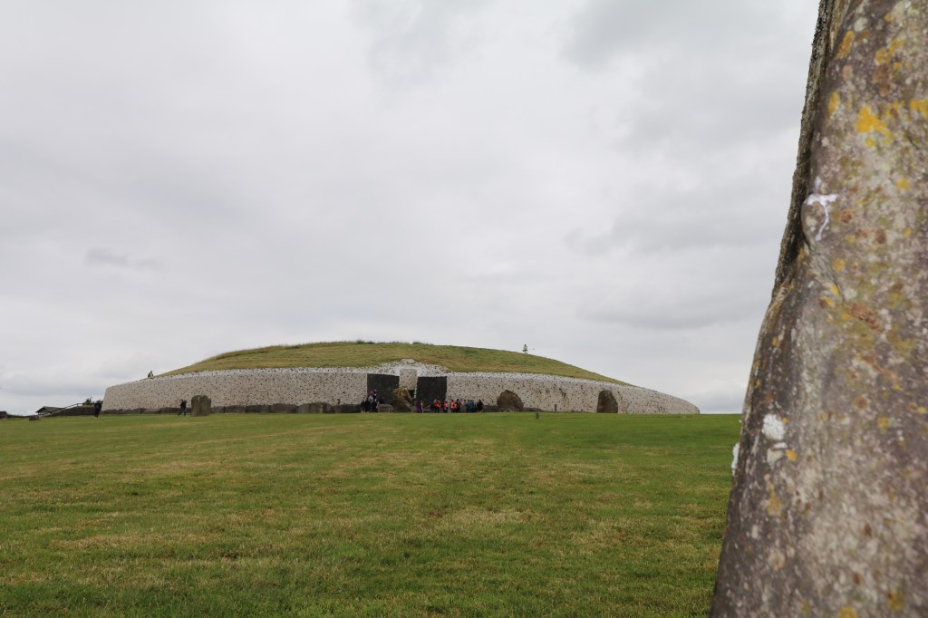
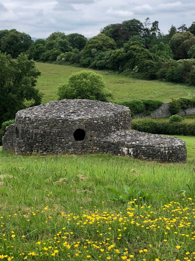
The entrance faces the rising sun. On the winter solstice, light enters the roof-box above the entrance, flashes down the narrow 60’ corridor and illuminates the back wall for seventeen minutes.img_0141 This engineering marvel measures 279’ wide, 39’ high, covering a little over an acre of land. Approximately 200,000 tons of rock, including a face of white quartz (collected from 25 miles to the south) and dark cobbled stone (collected from 25 miles to the north) outline the face of the temple.

547 huge inner slabs and outer kerbstones support the weighted structure.  It’s estimated that the monoliths were transported by river and then uphill to the site. Life is good and peace reigns, otherwise this marvel wouldn’t have been created.img_0029

There are many chamber and passage tombs all over Great Britain, but Newgrange is the grand cathedral because of extensive art work. The triple spiral represents the goddess, three female forms for eternity. Christianity stole the symbol, changing the threesome to the male Father, Son, and Holy Ghost after destroying matriarch religions and subjugating women as chattel.

Cupules carved into kerbstones appear in groups of 6 or 3. Is this a recording of events on a calendar or something else? Parallel lines lead to zigzags, or spirals. Unique triangles and diamond shapes might be a reminder to remain grounded to earth but keep focus on the spirit world. Or is the stylized shape a woman’s genitals, honoring where life begins?

Enter the passage, bending your head in submission. Notice the carvings inside, especially the outline of feminine hands. Think about them as we stand in the same spot. At the end, three side rooms face different directions: East, West, and North. Each chamber has a stone basin and two of them held cremated remains and bone remanents of at least 5 individuals. But the chamber on your right has a special carved basin made of granite. Human ash wasn’t found here. Maybe this was used as a birthing place with worshiped ancestors in the other chambers. Observing nature, would ancient people contemplate the complexity of reincarnation and renewal?

As decades progress, standing stones will be erected around the behemoth cairn. In our era there are 12 remaining but book the Bronze age time travel tour, to see a majestic 35 stone circle. You may also book the later Iron age journey, with the addition of pit circles and timber arches.  Six thousand years later, Newgrange remains a place of inspiration.

Hill of Tara

Let’s follow the light from burning bonfires atop the hill of Tara, the earthly portal to the ancient gods and the entrance of heaven. We are still in the stone age, but the later neolithic era. The 100 acre site is the coronation place for over 142 high Kings of Ireland and is the largest Celtic monument in Europe.  The ancient name was Liathdroim with dedication to the mother goddess Maeve. A text from around 600 A.D. states a contender for the throne from the chiefs of Ireland had to get drunk and marry the goddess in a ceremony. Women were treated as equals in this time, with all rights afforded men. In fact, a ring fort dedicated to a legendary warrior queen lies 1/2 mile from where we stand.

The oldest mound is a neolithic passage tomb that held hundreds of cremated remains as well as a rich burial of a young man. This is known as “the mound of hostages” and was constructed 5,000 years ago. The name implies the safety of this place where chieftains exchanged captive prisoners.

Moving to the north are ringforts, one with three banks known as the Rath of Synods and an Iron age earthwork with an internal ditch, thought to be the royal enclosure. This is the standing Stone of Destiny. If the would-be-king is righteous, the stone will roar three times. When I touched the phallic shaped stone, not even a whisper was heard. In myth, King Laoghaire is buried nearby in an upright position, dressed in full armor.

A grove of Hawthorn trees form a line. This is the tree of the goddess for seduction and fertility. To this day, women tie colored strings in the branches or leave notes and offerings.img_0095

Moving down the hill, there’s remains of a long ceremonial avenue or maybe a banquet hall. Debates continue over the function of the 656′ ruin. A 11th century text states a hall with over 140 entrances stood here.img_0164

If you visit in modern times, there’s a decommissioned Catholic church built above other ruins. Near an old wall there is an easily missed small standing stone. It’s believed that the figure of the fertility god, Cernunos is etched on the face.img_0160

Modern travelers can visit these sites as well as the Hill of Slane where St. Patrick defied the Celtic king in 433 AD, and 5th century Monasterboice, founded by St. Buite on a day trip from Dublin. We liked the small group size and reasonable rates with  https://www.daytoursunplugged.ie


The Perfect Pour

The Perfect Pour

To send a liquid or loose particles flowing or falling

From one container to another, or into, over, or on to something

This slideshow requires JavaScript.

 My thoughts are loose and flowing while the airplane slowly circles down to the tarmac. Emotions bubble up and I fight tears. I’m headed to the home of ancestors who left Ireland under times of starvation and death, not able to practise faith, marry legally, buy land or vote.

In the United States, these rights are considered my birthright. But the way the world is going, I may have to stand and fight to retain these freedoms. Those before me chose to leave on ships facing the western sun with hope-filled hearts.  Four generations later, I return, a legacy fulfilled and a spine built of grit.

Left behind are tales and songs of beautiful grass and hills, high cliffs and roaring surf.

My families love for Ireland remained as they endured racial slurs and menial jobs in America. Their suffering will never be taken lightly—for they built a strong cornerstone upon which my life was allowed to soar. I am truly blessed.

Once on the ground, my feet will tread a venerable path—be it dirt or cobblestone– across the Aran Islands, Cliffs of Moher, down to Dingle as we walk the Kerry Camino pilrimage. We trek across beautiful ballinskelligs with amazing beaches and visit the hermitage at Skelling Michael on a perfect day. Come along and explore rich stone age sites to Trinity College library and the Book of Kells (where my ancestors wouldn’t have been allowed).

I’ll wrap my hands around a mug of a perfectly poured Guinness at the Brazen Head, the oldest pub in Dublin, dating back to 1198. Did those before me indulge in the feel of thick foam on the tongue? Sipping Irish whiskey, my feet tap to music. Singing creates a fairy enchantment not allowing a single wallflower as we dance with each other and strangers alike. No one is shy in Ireland. Life is too short and we must live with our glasses full.

My Celtic heart warms. Welcome back home! Come over here for a hug! Amid much laughter, invisible roots plunge deep into the green grass. And there is the greatest gift of all—those who remained and endured welcome me as long-lost kin. Those who return, fall into their arms, melting away generations of separation and leaving a wellspring of love.

Back in the U.S.A., I kneel graveside, and whisper to those who worked so hard to make my life easier, “I completed the circle, because you could not.” I ken they hear and approve. Peace bridges time, flowing across oceans and distant lands, filling one heart and connecting to others. The perfect pour.