Half Moon Island, South Shetlands

This Quark Expedition is sailing back north, heading toward the Drake Passage and Ushuaia, Argentina. This is our last landing for Antarctica. Tomorrow we will be reluctant tourists, leaving this unique, beautiful place.

But for now we will enjoy Half Moon, a 1.2 mile long island  between Livingston  and Greenwich Islands in the South Shetlands.
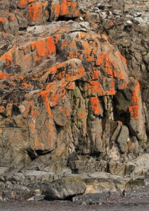
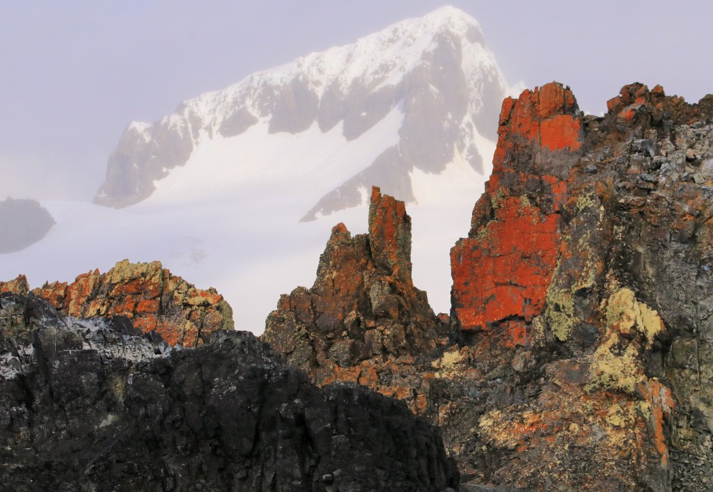
IMG_3026

beautiful lichen

The Argentine Camara station is located at one end

IMG_5683

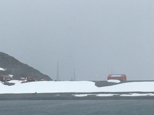
Argentine Camara Station

and a Chinstrap penguin nesting area at the other.

Blue-eyed Shags nest on top of orange lichen pinnacles against glaciated mountains beyond. IMG_3040 (2)

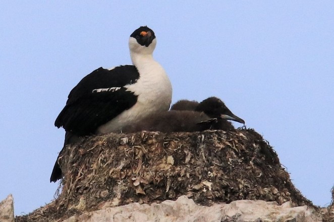
Before landing, we bounced in the zodiacs over choppy waters, checking out seals, shags, and this very cheeky skua who landed right next to me.

IMG_5696

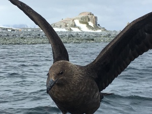
not sure if he wanted to be friends

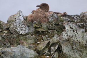
On land, amongst the rocks, broken penguin shells led to a mother skua snuggling with her chick.

IMG_3095

A single Adele penguin approached me with a tilt of the head and a confused look in its eyes. “How do I get back home?” The poor thing was obviously lost, speaking in penguin before wandering off in search of a more appropriate friend. IMG_3104

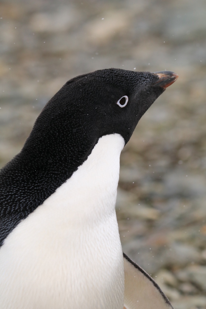
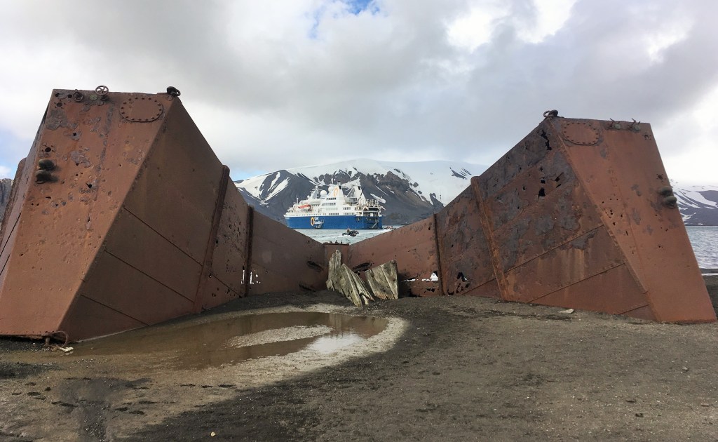
An old whaling craft remains on the beach, another testament of history in this part of the world. IMG_5698

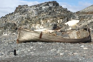
Half Moon Island is the breeding site of approximately 3,300 Chinstrap Penguins. Since this is our last landing, I spent time enjoying their antics and reflecting on all I’ve seen and learned.

I must admit to wiping a tear away, thinking about how much more there is to experience in this vast land.  This little penguin expressed my emotions back at me. IMG_3074

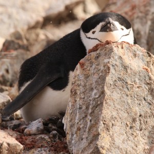
Before I left home, my friends asked strange questions . “WHY do you want to go there?” or “Where is that place….North or South pole?”

I hope my words and pictures have explained the wonders to be found here. More important, I hope I’ve inspired YOU to experience this adventure.

Good-bye from Antarctica.

This leaves a great big question—“Where shall I go next?” —trust me, I have a long list! Stay tuned. IMG_3068 (2)


DECEPTION ISLAND

Put yourself on a ship that navigates through a narrow opening called Neptune’s Bellows,

into the sunken caldera of an active volcano. A submerged rock lies about eight feet below the surface, smack-dab in the very middle of the channel. Bite your nails. The current is wild, and a shipwreck lies just inside the entrance as a reminder how quickly life can go bad. Red ash looks like folded curtains along the cliffs and you may see wisps of steam.

This isn’t the opening of a Hollywood thriller, this is  every day drama at Deception Island, in the South Shetland chain.IMG_2965

The sea floor is rising as magma pushes up. and some water temperatures have been recorded at 158 degrees Fahrenheit. During eruptions in the 1960’s the water was so hot, paint melted off of ships.

IMG_5675

hike up here and you can look down and out a “window” to the sea far below

There are so many cool reasons to experience this closely monitored site. The volcano has changed the micro-climate, allowing over 18 species of moss and lichens not found ANYWHERE else in Antarctica.Check out what it’s like to dive below the surface  with the Lindbald expedition : http://www.deceptionisland.aq/flora.php

IMG_2994 (3)
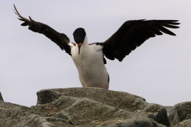
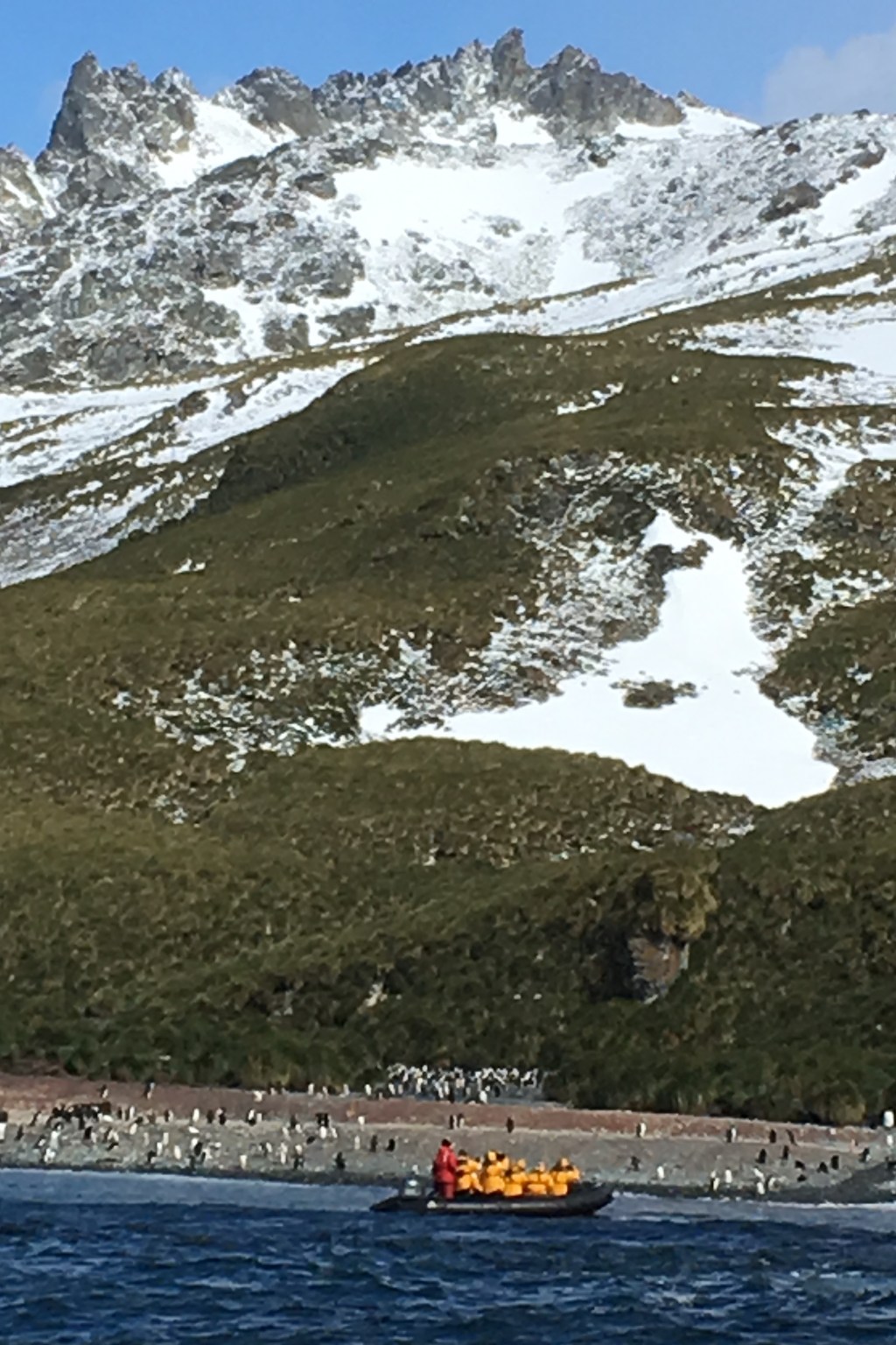
If you were a bird, would you want to hang out where it’s warm? Of course. The world’s largest chinstrap penguin colony with over 100,000 breeding pairs are here. We also saw blue-eyed shags (cormorants) with juveniles as big as the adults, nesting high above on the cliffs. (Thank goodness for that 600mm lens!)

Inside the caldera is the historic site at Whaler’s Bay where ruins of oil tanks, buildings and boats from the early 1900’s sit upon a black ash beach.

Two lonely graves still haunt me. This used to be the largest cemetery (35 men buried and 10 memorials to presumed drowned) in all of Antarctica before the last eruptions. I cannot let the memory go, knowing they are so far from home. IMG_2926

There’s an airplane hanger at one end. This is where the first trans-Antarctic flights began in 1928. IMG_2895

During and after WWII, the British destroyed some of the whaling remains, and set up a remote military post. There was great concern that the German’s would use Antarctica for nefarious reasons. After the war, the station returned to scientific study until 1967.

On the internet there are pictures of tourists soaking in pools dug into the warm sand. This isn’t allowed anymore (Hello? Environmental impact?) and there’s discussion about reducing the numbers of ships coming here. Count yourself l-u-c-k-y  if you can visit this unique historic and environmental site.

D’Hainaut Island

D’Hainaut is an island inside Mikkelsen Harbor on the south coast of Trinity Island. I’m betting this geography notation makes this location of ‘island inside another’ as clear as mud in a swamp.

For clarity, picture the Antarctic Peninsula which looks like a scorpion tail jutting up from the continent. There’s a scattering of islands along the Northwest side called the Palmer Archipelago and Trinity Island is within this chain.

In the era of whale slaughtering, factory ships moored off D’Hainaut and the remains of casks, ribs of boats, and bleached bones are still evident.IMG_5607 
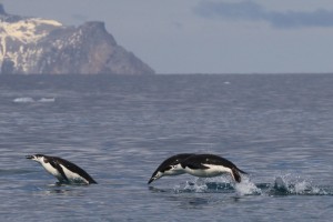
This day we chased through the harbor, following a group of Humpback Whales from a safe distance, shooting with our cameras rather than exploding harpoons.

There’s also a deserted Argentine refuge  from the 1950’s, a red hut a vivid highlight amongst snow-packed chinstrap penguin paths crisscrossing the site. The birds wander about, totally ignoring weaner Elephant seals head-banging and roaring.

Chinstrap and Gentoo babies here are much smaller and born later compared to those in the “warmer” north. In late December, chicks on South Georgia are about as big as their parents. Survivability is directly related to the amount of time the egg and chick remain warm before winter strikes again.  Regardless of the southern latitude, D’Hainaut remains an important breeding site.

This zen-like penguin community also ignored our single file conga line of yellow jackets as we carefully avoided their trails, called the ‘penguin highway’ to the sea Komossa512_DSC05890_Highway.

We also saw Snowy Sheathbills (nicknamed “Pattys”)

IMG_2649 sitting on the ice with a meal that looked suspiciously like the remains of a penguin chick. They also steal krill from penguins and are quite the scavengers. This is the only land bird native to Antarctica.

A Weddell seal enjoys a nap and a cute weaner peeks at us.

The last picture is of a Salp and is the most important thing I want you to take away from me today! This is a zooplankton related to jellyfish that form long necklace-like chains that float on the water. They eat phytoplankton and krill–just like everybody else in Antarctic waters.

Up to 200,000 tons of krill are harvested from the open ocean annually, even though the population continues to decrease from climate change. If tiny Krill are reduced, effects will devastate the entire cycle of life. Think about that next time you reach for the box of krill in the pharmacy or health food store. Are polar fish, birds, and mammals being sacrificed? Ultimately, the chain ends with us.

Please. Do not. Buy. Krill. Use another sustainable Omega-3.  

DMG432_wildlife-5

There’s a direct relationship to ocean temperature, krill, and salp populations. When there’s more ice, krill reproduce like mad. When ice melts and water warms, salp numbers increase. This isn’t a good thing, since salps aren’t as nutritious (lower in protein) for higher functioning animals.


Immense Tabular Icebergs, Kinnes Cove

Located on the SW end of Joinville Island, just off the Antarctic Peninsula, Kinnes Cove is named for the owner of an 1892 whaling expedition. Look at the beauty of these icebergs the ship had to carefully navigate through:

Our morning zodiac cruise was an exciting look at masses of blue ice in geometric formations.  Curious Adele penguins gathered on the floes, pausing to watch us as we watched them.

We passed what appears to be a rare albino whale. Not quite Moby Dick, which was a sperm whale, and this guy was traveling fast in the opposite direction of the ship. The albino condition can affect any mammal and a tell-tale sign is pink eyes. Albino Right Whales were filmed off the coast of Chile and South Africa last year, which theoretically isn’t far away from here.  We also saw Crabeater and Weddell Seals napping on the ice.

along a steep hill, penguins climbed as far as the eye could see. Nesting here are Gentoo, Chinstrap and Adele penguins.

Ice Ice Baby at Muckle Bluff

We are now on the south coast of Elephant Island in the South Shetland island chain at Muckle Bluff.  The word “muckle” is Scottish for “large” and everything here is supersized.

Let’s start with the Endurance Glacier (named for Shackleton’s expedition shipwrecked here for 4 1/2 months on the opposite side of the island). The calving glacial face at the ocean is 3.73 miles wide. It crosses the width of the 16.8 mile island, hugging 2,799 foot tall mountain peaks. This heavily crevassed glacier has retreated up to 5,000 feet between 1990 and 2015. Besides global warming, the exposed face is battered with winds over 100 mph and up to 60 foot waves.

On our zodiac cruise along the coast line, we found such beautiful blue ice formed into surreal shapes. We visited Macaroni and Chinstrap Penguin nesting grounds from the water. I love the macaroni penguin picture, because you can see the feathers clearly.

How about this for a jaw dropping backdrop?


After checking out things from the water we visited with the nesting Chinstrap Penguin colony. These little guys are quite the climbers.

It’s so steep that they hop-hop-hop all the way down when it’s time to go eat. I can’t imagine how many calories they need to eat each day just for this exertion.

We also saw bleached out whale bones. The baleen in the second picture is from a whale’s mouth, used to sieve food and expel water. The ends look and feel like straw. The middle fluted part feels like a fingernail. Long ago, baleen was used in whips, corset stays and other products.img_2150

The picture above is one of my favorites. The lady is taking a picture out to sea, but look at all the penguins lined up behind her–and she doesn’t know it. Makes me smile.

There are many special critters  here. On the left is one of the best Antarctic predators– the Leopard Seal. Yet, walking behind him wobbles dinner–the penguin. Leopard Seals can weigh 1,300 pounds and  are 11 feet long. They do not breed on land like other seals and are loners. Their babies are born on the ice, nestled in a freezing hole by the mother. They’re only predator is a killer whale. Zoom on the picture of the Leopard seal and the Weddell seal to the right. Are they crying? Don’t shed tears for them—this is the way they eliminate saline from the ocean. Also, examine the flipper of the Weddell. Do you notice something odd? Fingernails, perhaps? They are both “earless” seals.img_1997

Watching “porpoising” penguins is mesmerizing. So fast. So graceful!

Cooper Bay and Drygalski Fjord

img_1581-2This is a juvenile blue-eyed Cormorant, still in brown plumage. A giant Petral takes off before me. img_1505


Cooper  Bay is a mountainous land carved by glaciers on the Southern end of South Georgia.
Here you’ll find the largest nesting site of Chinstrap penguins on South Georgia.  Can you guess why some of them have pinkish-brown staining? They eat mostly Krill and some Shrimp. These guys laid in guano and need to take a bath.

Cruising along the coast, bumping around kelp festooned boulders and jutting pieces of rock, we found a large group of Macaroni Penguins. Big, soft snowflakes began to fall, making the scene otherworldly. These birds weigh about twelve pounds and stand about 28″ tall. They get their unusual name from 18th century slang for a person who is flamboyant in their dress, rather than having cheesy-noodle crowns.

Just before leaving this large sub-Antarctic island (we aren’t at the continent yet), the captain sailed the ship through narrow (seven miles long) Drygalski Fjord. Glacier scoured mountains soar out of the ocean, blocking the sky. We floated through brash ice, and heard the shot-gun blast of calving ice falling into the water around us.

At the terminal end is  Risting Glacier, named for a Norwegian whaling historian. These pictures were taken from the ship, so try to comprehend the magnitude of the tidal face looming many stories tall and burying almost five miles of terrain.